A good knowledge of the map key is essential. Some instructions will make use of the information on the map like the gradient signs, churches, pubs, POs, ETLs, road numbers etc.
Such instructions might read: Under a railway, ETL, A74, PO, church with a tower, ford, HWM.
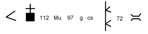
A list of features may include spot heights or letters of a placename that 'interfere' with the road as shown on the map. Some of the features may be drawn using the same symbols as on the map as in this example:
These instructions would mean: Go up a hill with a gradient symbol, pass a church (with a tower), through spot height 112, through where the letters "Mu" from a place name cut the road, through spot height 97, through where a 'g' , then the letters 'cs' cut the road, under an electricity transission line, through spot height 72 and over a bridge.
Tip: If you cut the key off the map keep it with you as you may need it!
In a particularly hilly area a route may be given entirely by a string of gradient symbols, or by the abbreviations D for Down and U for Up. The double gradient symbol would tie up with a double symbol (very steep hill) on the map.
> > > < << > < < <
D D D U U D U U U
These are often mixed up with abbreviations O for Over and U for Under, where you go over and under bridges or under power lines shown on the map. So U can mean Under or Up which you'll have to decide in each case by studying the map.