HERRINGBONES

Herringbones, or Straight Lines as they are sometimes called, are a very simple method of defining the route, once you understand how they work. Imagine the route drawn with a little bit of of road leading away from each junction, then pulled tight like a piece of string. The route that you take is then a straight line, missing roads on the left and right accordingly. The way to convert the herringbone to a route on your map is to consider 3-way junctions as leave a road on the left or leave a road on the right.
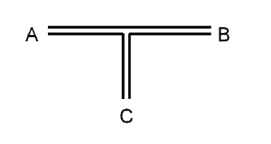 If the junction on the map is shaped like this, going straight on from A to B you would leave a road on the right. However also turning from C to A or from B to C you would leave a road on the right. For each of these three cases the junction on the herringbone will look the same. Similarly, to leave a road on the left you could be going straight on from B to A, taking a right from A to C, or turning right at the T-junction from C to B.
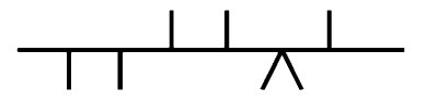
 The two example herringbones on this page will take you from the start to finish of this section via different routes. Notice how the crossroads appears when you are turning left, rather than going straight across.
It's usually expected that herringbones will start from the left, but rally organisers often turn them around, maybe giving you a clue in the instructions, like "the following herringbone describes the route from TC4 to TC3", so read all instructions carefully. When you come to a crossroads on your map and it fits with a crossroads on the herringbone, it's a good indication that you're on the right route. If not, then try starting at the other end!