 The name of this type of navigation comes from the Tulip Rally, which first used it in the 1950s.
The name of this type of navigation comes from the Tulip Rally, which first used it in the 1950s.
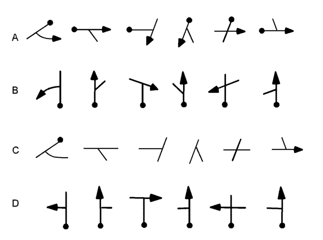
Tulip, or ball and arrow instructions, are simple diagrams of the route junctions with the ball indicating where you come from and the arrow indicating where you are going to. Normally they are given in order.
Tulips may be orientated as on the map, or turned around so that the ball is always at the bottom, or most of the balls and arrows may be left off deliberately. Sometimes they may be squared up. Here are a few variations on the same route described with tulips:
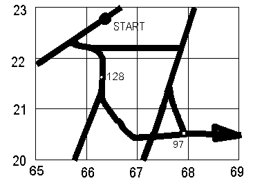
Commonly used to describe the route of non-competitive link sections, the Tulip Roadbook uses tulip symbols to detail a route, but provides additional information on distances, road signs etc. Here is an example for the same route:
| Intermediate Distance | Total Distance | Tulip | Comment | Distance to Go |
| 0.00 | 0.00 | TC3 |
Time Control |
3.97 |
| 0.52 | 0.52 |

|
Swan Lane | 3.45 |
| 0.36 | 0.88 |

|
Newtown 3 | 3.09 |
| 0.95 | 1.83 |

|
Give Way Join A286 |
2.14 |
| 0.49 | 2.32 |

|
1.65 | |
| 0.53 | 2.86 |

|
West Street | 1.11 |
| 0.44 | 3.30 |

|
0.67 | |
| 0.67 | 3.97 | TC4 |
Time Control |
0.00 |